By the end of the week, most of the country will have seen rain, and it's all from one system! First it was WA, and now a low pressure trough is spreading rain and storms across the southern NT and most of SA. The moisture-ladden cloud will continue to spread east affecting western parts of NSW and QLD on Wednesday, before moving through much of eastern Australia during Thursday, Friday and the beginning of the weekend.
In the 24 hours leading up to 9am Monday, most parts of southwest WA picked up 5-15mm with Perth one of the only places to miss out. There were isolated pockets that received torrential downpours underneath intense thunderstorms. This included 53mm in Wongan Hills (Central Wheatbelt), its heaviest October rainfall in over 100 years!
Today, the rain and thunderstorm activity is affecting southern parts of the NT and most of SA. This rainfall comes as a relief to the Red Centre which has been ravaged by bushfires over the last six weeks. Widespread falls of 5-15mm are expected but once again, these isolated thunderstorms have the potential to be severe with heavy falls, damaging winds and small hail. The rain is likely to arrive in Adelaide during the late afternoon/evening.
On Wednesday/Thursday, rain and storms will spread across most western and inland parts of QLD, NSW, VIC and TAS, before affecting the east coast late Thursday/Friday and the weekend. Isolated pockets could receive heavy falls from thunderstorm activity.
Tuesday, October 4, 2011

Tuesday, August 30, 2011
Storms on the way for SE QLD!
Spring is almost here and we're already getting a taste of the type of weather it brings in southeast QLD- afternoon storms!!
This afternoon we'll see showers and storms developing in QLD anywhere east of the Northern Goldfields and Maranoa and Warrego districts, including Southeast QLD. The atmosphere is unstable and these storms have the potential to be severe with flash flooding and isolated falls of around 50mm, as well as large hailstones and damaging winds.
Last night, storms swept through parts of QLD bringing the heaviest falls to the Central Coast and Capricornia districts (Bingebang Weir 91mm, Mt Christian 80mm, St Lawrence 51mm, Prospect Creek 43mm), with around 10-20mm in parts of Maranoa and Warrego and Darling Downs (Toowoomba Ap 18mm, Yuleba 19mm, Dalby 12mm). This afternoon, the Southeast Coast will also come into play with Brisbane likely to be affected.
Monday, August 15, 2011
Journey to the centre of the earth!
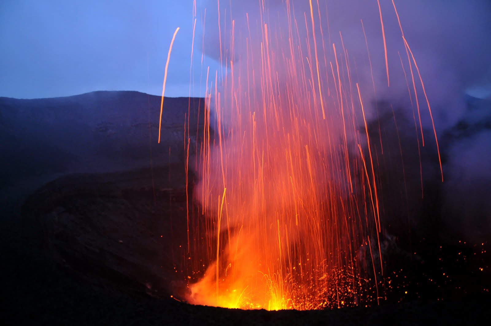
Last weekend, I experienced the incredible force of nature again, only this time it wasn't coming from the sky, but the earth. Mt Yasur volcano on Tanna Island in Vanuatu is the most accessible active volcano on the planet and I couldn't believe how close I was able to get to the roaring earth and spitting lava. The blast of lava sounded like bombs exploding and the fireworks display of fire, lava, rocks and smoke was extraordinary.

The road to Mt Yasur is more like a dirt track with enormous potholes and takes about 2 hours each way. As you approach the volcano, vegetation and villages disappear to reveal a stark, grey moonscape plain of volcanic ash, with Mt Yasur blowing smoke and roaring in the distance.

As the 4WD descends up the volcano, steam leaks out from the volcanic earth. Just before the short walk up to the volcano rim you'll find a post box- the only one on a volcano in the world!

Monday, June 27, 2011
Big week of rain for southwest WA!
It's set to be a big week of rainfall for southwest WA thanks to a number of cold fronts crossing the region. The most significant of these fronts is hitting on Tuesday morning and it's expected to deliver as much as 25-50mm for the west coast including Perth, with 5-15mm possible for the Central Wheatbelt favouring the western half. Most of this rain will occur during Tuesday morning with isolated showers during the afternoon. The bad news is that this front is likely to be accompanied by severe weather. Damaging winds are possible ahead the front on Tuesday morning with squally storms potentially generating powerful winds also. Damaging winds with gusts over 90kmh are strong enough to bring down trees and power lines.
The next front is due on Thursday with another 5-15mm expected for the west coast and lighter falls further inland. By the end of the week as much as 50-100mm could fall on the west coast with anywhere between 10-20mm for the Wheatbelt.
This comes on top of heavy rain just last Friday where Perth saw 57mm! This brings Perth's June rainfall so far to 128.2mm, just 6.5mm short of the June monthly average. Needless to say, many parts of the southwest will have recorded above average rain for June by the end of the month.
The next front is due on Thursday with another 5-15mm expected for the west coast and lighter falls further inland. By the end of the week as much as 50-100mm could fall on the west coast with anywhere between 10-20mm for the Wheatbelt.
This comes on top of heavy rain just last Friday where Perth saw 57mm! This brings Perth's June rainfall so far to 128.2mm, just 6.5mm short of the June monthly average. Needless to say, many parts of the southwest will have recorded above average rain for June by the end of the month.
Friday, May 27, 2011
Finally, some more rain for Perth and WA south-west
After its driest year on record in 2010 and below average rainfall so far this year, much of WA’s southwest is in desperate need of rainfall. But I have some good news! Next week a couple of strong cold fronts will bring a wet change to the southwest, but this may be accompanied severe weather.
On Monday, it’s a very “winter-type” set-up with a strong cold front bringing rainfall, windy conditions (potentially damaging winds with gusts over 90kmh) and severe thunderstorms. Showers will continue on Tuesday with onshore winds before another cold front brings more rainfall on Wednesday.
Between the two systems, widespread falls of 25-50mm are possible for the Perth area with 50mm plus for towns south of Perth such as Bunbury and Busselton. Rain totals will drop rapidly heading inland with 1-20mm possible in the Wheatbelt, favouring the western side.
Ahead of this wet and windy weather, try and tie down any loose items and be prepared for a wet and slippery commute to work on Monday.
On Monday, it’s a very “winter-type” set-up with a strong cold front bringing rainfall, windy conditions (potentially damaging winds with gusts over 90kmh) and severe thunderstorms. Showers will continue on Tuesday with onshore winds before another cold front brings more rainfall on Wednesday.
Between the two systems, widespread falls of 25-50mm are possible for the Perth area with 50mm plus for towns south of Perth such as Bunbury and Busselton. Rain totals will drop rapidly heading inland with 1-20mm possible in the Wheatbelt, favouring the western side.
Ahead of this wet and windy weather, try and tie down any loose items and be prepared for a wet and slippery commute to work on Monday.
Wednesday, May 11, 2011
Extreme cold chills the southeast

Many cities and towns in south-eastern Australia shivered through their coldest morning so far this year. Sub-zero temperatures brought frost to places including Glenn Innes and Young with -5, Camden with -1 and Tamworth with -2! Even Richmond (NSW)and Charlesville (QLD) woke up to their first frost for the year.
Day-time temperatures are also well below average across much of southern and eastern Australia. Check out the following forecast maximum temperatures today!
- Toowoomba, QLD: 16 degrees (4 below average)
- Mt Isa, QLD: 22 degrees (6 below average)
- Orange, NSW: 6 degrees (8 below average)
- Young, NSW: 10 degrees (8 below average)
- Ballarat, VIC: 7 degrees (7 below average)
- Melbourne, VIC: 13 degrees (4 below average)
- Hobart, TAS: 11 degrees (3 below average)
- Launceston, TAS: 12 degrees (4 below average)
- Renmark, SA: 16 degrees (4 below average)
- Adelaide, SA: 16 degrees (3 below average)
And if this isn't bad enough, icy south-westerly winds will make it "feel" a few degrees colder!
Snow has also been coating the NSW and VIC slopes and ranges. Most alpine areas have had around 10cm of snow but I've also had reports of 15-20cm at Mt Buller this morning (See pic by Tony Harrington above).
The cold snap is here to stay for the rest of the week and for some places, tonight may be even colder than last night so rug up!
Sunday, March 20, 2011
Sydney's Weekend Washout!
It has been raining non-stop in Sydney this weekend with massive rain totals recorded between the Hunter and South coasts over the last 2 days. So where is this deluge coming from and when will it stop?!
Well, the atmosphere is completed saturated and when it's like this all it needs is a "trigger" for a heavy downpour. In this case, the "trigger" is a small-scale low pressure trough that formed off the NSW coast. The very moist air has been feeding into this trough causing widespread torrential rain in Sydney, the Hunter, South Coast and Illawarra. With so much heavy rain falling over a short time period, flash flooding is likely.
Over the last 48 hours, the heaviest falls have generally been in coastal suburbs, closest to this trough. In 24 hours to 9am Sunday morning, we've seen widespread falls of over 100mm with as much as 166mm in Little Bay, it's heaviest March rain since 1975. Other notable falls include:
Avalon- 139mm
St Ives- 179mm
Turrumurra- 175mm
Belrose- 137mm
North Manly-130mm
Sydney Airport- 100mm
Further south, Albion Park recorded 137mm, Wollongong 129mm and Barrengarry 210mm!! The rain has been lighter further west with up to 50mm in the Warragamba catchment area. Considering how dry it has been, this is unlikely to lead to any significant rises.
So- what next? Heavy rain will continue during Sunday, easing later as the trough moves away. But heavy rain is likely to return on Monday as another low pressure trough comes in from the west. The wet weather should start to ease on Tuesday.
Well, the atmosphere is completed saturated and when it's like this all it needs is a "trigger" for a heavy downpour. In this case, the "trigger" is a small-scale low pressure trough that formed off the NSW coast. The very moist air has been feeding into this trough causing widespread torrential rain in Sydney, the Hunter, South Coast and Illawarra. With so much heavy rain falling over a short time period, flash flooding is likely.
Over the last 48 hours, the heaviest falls have generally been in coastal suburbs, closest to this trough. In 24 hours to 9am Sunday morning, we've seen widespread falls of over 100mm with as much as 166mm in Little Bay, it's heaviest March rain since 1975. Other notable falls include:
Avalon- 139mm
St Ives- 179mm
Turrumurra- 175mm
Belrose- 137mm
North Manly-130mm
Sydney Airport- 100mm
Further south, Albion Park recorded 137mm, Wollongong 129mm and Barrengarry 210mm!! The rain has been lighter further west with up to 50mm in the Warragamba catchment area. Considering how dry it has been, this is unlikely to lead to any significant rises.
So- what next? Heavy rain will continue during Sunday, easing later as the trough moves away. But heavy rain is likely to return on Monday as another low pressure trough comes in from the west. The wet weather should start to ease on Tuesday.
Subscribe to:
Posts (Atom)